Nawww 'they" ain't doin nuthin !!! just keep worry about your fantasy team or idol :o
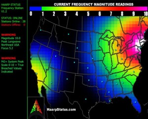 Looking back at the development of hurricane Sandy.
Thursday morning update from HAARPStatus.com:
The Western USA frequency is subsiding, however the Eastern USA frequency is rising, now over an 8.2 Magnitude.
An 8.2 is significant and this rise has been detected in the area for almost a week now. It has not yet peaked.
We think Hurricane Sandy is being steered into the USA. Since this showed up over a week ago before anyone started talking about the storm, do feel we are seeing a controlled storm. If the storm tries to leave into the ocean away from the United States and steers back west toward it then it would prove that HAARP can steer storms.
Follow Hurricane Sandy on our partner’s page at TheWeatherSpace.com’s Facebook Page by Clicking Here.
(Editor’s note: For those who have doubted HAARP or this prediction, please take note of this recent story from Beforeitsnews.com’s Barracuda linked below this paragraph from his story. Also note the latest HAARP graphic from HAARPStatus.com at bottom of this story)
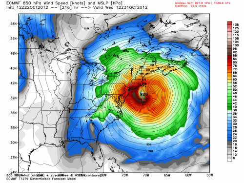
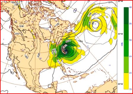
“This could be one hell of a monster storm if all the ingredients come into place .They are saying it has potential to become a perfect storm. It’s still early and alot could happen.According to this Computer Model I hunted down it looks like a direct hit for the Delmarva Peninsula area ,if it is correct and follows this path?I’m on Long Island so even with that track it could get very nasty here too.”
Much more @ /weather/2012/10/this-computer-model-shows-sandy-slamming-into-the-delmarva-peninsula-area-2437266.html
According to the website HAARPStatus.com, any time we get a HAARP frequency magnitude reading over M7, it is quite rare and special attention must be directed when readings go that high. Severe storms are associated with this reading, which if a short spike can be a nearby event and a long duration and slow build being a large scale change.
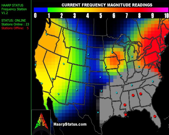
I bring this to your attention due to the following events which I believe are strongly linked. Am I correct? Look this over and decide for yourself. First of all, let’s take a look at the latest HAARPStatus chart showing the current HAARP frequency magnitudes across America. From http://www.haarpstatus.com/haarpstatus/haarpmap.html
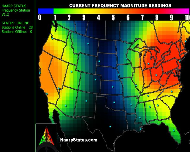
One look at the map above informs us that all across the East Coast from the Virginia/North Carolina border up to New England shows a HAARP frequency magnitude in the 7 to 8 range, associated with severe storm outbreaks. Should we be concerned or is this just something that might better be called ‘conspiracy theory’?
To attempt to get an answer for that question, let’s go ahead and take a look at something that was just brought to my attention by a thread at the website Godlike Productions. From the thread:
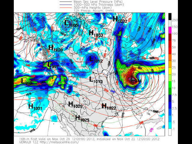
“Over the past few days many forecast models are predicting an east coast storm that could only be described as EPIC. The latest run of the CMC (Canadian forecast Model), has this storm arriving Sunday/Monday for the east coast, with a peak central pressure of 94.4. ABSOLUTELY EPIC in nature. The winds and rain being predicted are unreal with gusts in many areas could exceed 120km/h or 70mph for several hours. Be advised this storm is being predicted a week in advance and the models could change things in the coming days.
This storm will gather strength as it moves up the coast while being sandwiched between two HIGH pressure systems. This storm has already started forming in the tropics south of Florida.
The scary thing about all this, is it being a rather rare event, and with many of the forecasting models predicting this scenario, it makes it very strange and concerning. A central pressure of 94.4 could very well be the lowest central pressure ever recorded along the east coast and US Northeast. A possible storm for the ages folks.”
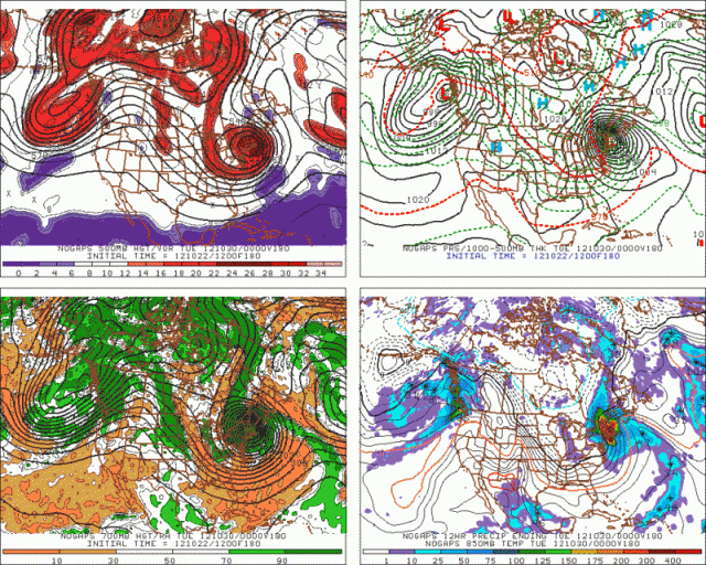
A look at the forecast maps below show something absolutely startling, take a look! The potential mega-storm spoken about in the GLP thread appears to be ready to occur in nearly the exact same location as the mega-high HAARP frequency readings! Take a look at it! Is this just a coincidence? I think not; there are no coincidences, only the illusion of coincidence.
Have you yet heard anything from the mainstream media over a potential mega-storm brewing for the East Coast for next week yet? Nothing from most of them but from Climate Central, we get the following: “Grim Storm Scenarios Looming For Mid-Atlantic, Northeast”
“what could happen after that that has some weather forecasters pondering some rather bizarre scenarios — think if a hurricane and nor’easter mated, possibly spawning a very rare and powerful hybrid storm, slamming into the Boston-to-Washington corridor early next week, with rain, snow, damaging winds, and potential storm surge flooding.” Source: http://www.climatecentral.org/blogs/tropical-storm-could-threaten-east-coast-in-an-unusual-way-15145
I know that there are probably many people out there reading this who still think that all of this is conspiracy theory madness and that human beings have not yet been able to ‘master the weather’ and ‘play God’. I can only ask you to please watch the video below from CBC News with an open mind.
Uploaded by zombiehellmonkey on Aug 20, 2010
Before the Hurricane: “East Coast HAARP Mega-Storm Brewing For Next Week”
 Looking back at the development of hurricane Sandy.
The Western USA frequency is subsiding, however the Eastern USA frequency is rising, now over an 8.2 Magnitude.
An 8.2 is significant and this rise has been detected in the area for almost a week now. It has not yet peaked.
We think Hurricane Sandy is being steered into the USA. Since this showed up over a week ago before anyone started talking about the storm, do feel we are seeing a controlled storm. If the storm tries to leave into the ocean away from the United States and steers back west toward it then it would prove that HAARP can steer storms.
Follow Hurricane Sandy on our partner’s page at TheWeatherSpace.com’s Facebook Page by Clicking Here.
(Editor’s note: For those who have doubted HAARP or this prediction, please take note of this recent story from Beforeitsnews.com’s Barracuda linked below this paragraph from his story. Also note the latest HAARP graphic from HAARPStatus.com at bottom of this story)
“This could be one hell of a monster storm if all the ingredients come into place .They are saying it has potential to become a perfect storm. It’s still early and alot could happen.According to this Computer Model I hunted down it looks like a direct hit for the Delmarva Peninsula area ,if it is correct and follows this path?I’m on Long Island so even with that track it could get very nasty here too.”
Much more @ /weather/2012/10/this-computer-model-shows-sandy-slamming-into-the-delmarva-peninsula-area-2437266.html
According to the website HAARPStatus.com, any time we get a HAARP frequency magnitude reading over M7, it is quite rare and special attention must be directed when readings go that high. Severe storms are associated with this reading, which if a short spike can be a nearby event and a long duration and slow build being a large scale change.
I bring this to your attention due to the following events which I believe are strongly linked. Am I correct? Look this over and decide for yourself. First of all, let’s take a look at the latest HAARPStatus chart showing the current HAARP frequency magnitudes across America. From http://www.haarpstatus.com/haarpstatus/haarpmap.html

One look at the map above informs us that all across the East Coast from the Virginia/North Carolina border up to New England shows a HAARP frequency magnitude in the 7 to 8 range, associated with severe storm outbreaks. Should we be concerned or is this just something that might better be called ‘conspiracy theory’?
To attempt to get an answer for that question, let’s go ahead and take a look at something that was just brought to my attention by a thread at the website Godlike Productions. From the thread:
“Over the past few days many forecast models are predicting an east coast storm that could only be described as EPIC. The latest run of the CMC (Canadian forecast Model), has this storm arriving Sunday/Monday for the east coast, with a peak central pressure of 94.4. ABSOLUTELY EPIC in nature. The winds and rain being predicted are unreal with gusts in many areas could exceed 120km/h or 70mph for several hours. Be advised this storm is being predicted a week in advance and the models could change things in the coming days.
This storm will gather strength as it moves up the coast while being sandwiched between two HIGH pressure systems. This storm has already started forming in the tropics south of Florida.
The scary thing about all this, is it being a rather rare event, and with many of the forecasting models predicting this scenario, it makes it very strange and concerning. A central pressure of 94.4 could very well be the lowest central pressure ever recorded along the east coast and US Northeast. A possible storm for the ages folks.”
A look at the forecast maps below show something absolutely startling, take a look! The potential mega-storm spoken about in the GLP thread appears to be ready to occur in nearly the exact same location as the mega-high HAARP frequency readings! Take a look at it! Is this just a coincidence? I think not; there are no coincidences, only the illusion of coincidence.
Have you yet heard anything from the mainstream media over a potential mega-storm brewing for the East Coast for next week yet? Nothing from most of them but from Climate Central, we get the following: “Grim Storm Scenarios Looming For Mid-Atlantic, Northeast”
“what could happen after that that has some weather forecasters pondering some rather bizarre scenarios — think if a hurricane and nor’easter mated, possibly spawning a very rare and powerful hybrid storm, slamming into the Boston-to-Washington corridor early next week, with rain, snow, damaging winds, and potential storm surge flooding.” Source: http://www.climatecentral.org/blogs/tropical-storm-could-threaten-east-coast-in-an-unusual-way-15145


I know that there are probably many people out there reading this who still think that all of this is conspiracy theory madness and that human beings have not yet been able to ‘master the weather’ and ‘play God’. I can only ask you to please watch the video below from CBC News with an open mind.
Uploaded by zombiehellmonkey on Aug 20, 2010
“It isn’t just conspiracy theorists who are concerned about HAARP.
In January of 1999, the European Union called the project a global
concern and passed a resolution calling for more information on its
health and environmental risks. Despite those concerns, officials at
HAARP insist the project is nothing more sinister than a radio science
research facility.”“Electromagnetic weapons … pack an invisible wallop
hundreds of times more powerful than the electrical current in a
lightning bolt. One can blast enemy missiles out of the sky, another
could be used to blind soldiers on the battlefield, still another to
control an unruly crowd by burning the surface of their skin. If
detonated over a large city, an electromagnetic weapon could destroy all
electronics in seconds. They all use directed energy to create a
powerful electromagnetic pulse.”“Directed energy is such a powerful
technology it could be used to heat the ionosphere to turn weather into a
weapon of war. Imagine using a flood to destroy a city or tornadoes to
decimate an approaching army in the desert. The military has spent a
huge amount of time on weather modification as a concept for battle
environments. If an electromagnetic pulse went off over a city,
basically all the electronic things in your home would wink and go out,
and they would be permanently destroyed.”
The latest HAARPStatus graphic shows high 8 magnitude approaching 9. Per HAARPStatus: M6 – M9 - Significant change is expected. Anything over M7 is rare and special attention must be directed when readings go seven and higher. Severe storms are associated with this reading, which if a short spike can be a nearby event and a long duration and slow build being a large scale change. LARGE SCALE CHANGE! Is this our October surprise???
Update weather map from Barracuda’s story linked above.
 Source —>Before It’s News
The latest HAARPStatus graphic shows high 8 magnitude approaching 9. Per HAARPStatus: M6 – M9 - Significant change is expected. Anything over M7 is rare and special attention must be directed when readings go seven and higher. Severe storms are associated with this reading, which if a short spike can be a nearby event and a long duration and slow build being a large scale change. LARGE SCALE CHANGE! Is this our October surprise???

Update weather map from Barracuda’s story linked above.
 Source —>Before It’s News


No comments:
Post a Comment