---BREAKAWAY CIVILIZATION ---ALTERNATIVE HISTORY---NEW BUSINESS MODELS--- ROCK & ROLL 'S STRANGE BEGINNINGS---SERIAL KILLERS---YEA AND THAT BAD WORD "CONSPIRACY"--- AMERICANS DON'T EXPLORE ANYTHING ANYMORE.WE JUST CONSUME AND DIE.---
Hey Oklahoma ! you know where that motherfucker lives (piece of shit pig!)
??? Our Forefathers "knew" what 2 do !
“Did you see her collar fly off when I shot her? That was awesome!” Adan Salazar
Infowars.com
March 21, 2014
An Oklahoma police officer shot and killed a family’s dog and later
laughed about it to a responding animal control unit, reports claim.
Pit bull dog, “Cali” / Image: Facebook
On
Wednesday, Ardmore resident Sarah Jo Ellen Brown reportedly arrived
home to news that her family’s pit bull dog “Cali” was dead.
“When the owner, Sarah, got there, the officer said, ‘We shot your dog, she’s dead,” a Change.org petition launched in Cali’s honor states.
According to multiple sources, Ardmore Police Sergeant Brice Woolley responded to a call regarding a dog that had escaped and was wandering the neighborhood.
“I’m not waiting for animal control,” Sgt. Woolley allegedly stated as he grabbed his shotgun to confront the doomed pooch.
As pictures show, Sgt. Woolly, who works the day shift patrol in
Ardmore, next shot the dog, killing it immediately. “She had done
nothing to provoke the officer,” the Change petition, which has been
signed over 2,900 times, notes. “Did you see her collar fly off when I shot her? That was awesome,” Brown claims Woolly bragged to the responding animal control officer, who supposedly replied, “We’ll just write in the report that it tried to attack you and others in the neighborhood.”
Sgt. Woolly has a checkered past with the department. Woolly’s name last year appeared in a complaint
lodged by one of his fellow officers, who claimed he suffered
“intentional infliction of emotional distress,” among other trauma, at
the hands of the department.
Last year, Woolly was also specifically named in a complaint
by an Ardmore citizen accusing him of multiple violations, including
conducting a warrantless entry and search of the citizen’s home.
“Fuck you bitch! What do you think about this? I hope you enjoy jail
bitch. I’ve finally got you on something and you’re going back to
prison,” Woolly is reported to have told the person.
Way back in November 2000, Woolly, who at the time worked for the Tishomingo Police Department, also shot and killed 36-year-old Jeff Wayne Baxter, who he claimed had attacked him. “Facts
came out in the lawsuit and Brice Woolly’s account of the murder didn’t
correspond with the dash cam footage. The City of Tishomingo settled
that lawsuit in the murder of Jeff Baxter,” an article at TheFreeThoughtProject.com claims. “During the lawsuit proceedings, it was
discovered officer Brice Woolly failed multiple psychological exams
required to be a police officer. At some point, Woolly was allowed to
join the ranks.”
In the days since the incident transpired, a Facebook page
has been created dedicated to seeking “Justice for Cali.” A walk in
memory of Cali is scheduled to take place tonight, and a group is also
planning to assemble at the Ardmore police department tomorrow with over
580 people already pledging to attend. As for legal remedies, the
page’s admin says it “is being handled.”
See more photos of docile Cali below, via Facebook. Warning: some of the photos are graphic.
This article was posted: Friday, March 21, 2014 at 4:56 pm
Syngenta halts GMO corn seed sales in Canada due to importer resistance
What happens when more people hear about the damaging effects of GMO? You run out of a viable market for your goods
By Christina Sarich | Natural Society
That’s what is happening to Agro-giant, Syngenta, who halted its commercial sales of a new GMO corn strain due to lack of approval for their genetically modified goods.
The company has already been accused of wire tapping a prominent scientist who
let the world know just how bad one of their widely-used chemicals,
atrazine, was for the endocrine system. Apparently even stalking an
honest researcher isn’t enough to prevent a black-listing of their own
genetically modified corn containing the Agrisure Duracade trait, which
supposedly protects crops from rootworms.
This corn was to be ready for planting the first time this year, but
now without overseas importer’s OK – including Japan, Mexico and South
Korea - Syngenta is left holding their proprietary seeds themselves.
Syngenta’s corn has also not been approved for two larger markets it was
hoping to woo, China or the European Union.
“While the vast majority of the Canadian corn crop is
typically directed to domestic markets in North America. . . we want to
ensure the acceptance of any trait technology grown in Canada meets
end-market destination requirements,” says Syngenta in a statement.
“The commercialization of Duracade could ‘further contaminate, slow down, gum up’ shipments of U.S. corn to China”, Rich Feltes, vice president of research for commodity brokerage R.J. O’Brien, said in a recent interview.
Corn containing the Duracade trait meant for Canada will be
returned to sender, and exporters as well as farmers are relieved since
they feared an unapproved trait could disrupt Canada’s grain supply
trade. One of Canada’s biggest grain company Vice Presidents, Peter
Entz, at Richardson International Ltd is elated to hear that Syngenta
won’t sell Duracade corn in his country. He ships large volumes of corn
to other countries, including the EU, where many GMO bans are being
implemented, and Duracade corn is currently not authorized.
U.S. farmers are still at risk, however, since China or Europe could
refuse shipments of corn that have traces of the Duracade corn,
especially since different varieties of corn are harvested, transported,
and stored together.
Sadly, farmers in Canada who were desirous of planting Syngenta’s new
corn will instead plant other Sygenta seeds instead of opting for
non-GMO alternatives. You would think that this one trade issue would
speak to the farmers’ bottom line and encourage them to abandon GMO
farming, but instead they just look to other genetically modified
suicide seed.
Chinese authorities have already rejected more than 887,000 tonnes of
U.S. corn and corn products containing another unauthorized genetically
modified Syngenta corn trait, Agrisure Viptera – MIR 162, which is
still unapproved in the country.
(Photo: Wikimedia Commons)
Russia Could Crush the Petrodollar Russia threatened to dump its U.S. treasuries if America imposed sanctions regarding Russia’s action in the Crimea. Zero Hedge argues that Russia has already done so. But veteran investor Jim Sinclair argues that Russia has a much scarier financial attack which Russia can use against the U.S.
Specifically, Sinclair says that if Russia accepts payment for oil
and gas in any currency other than the dollar – whether it’s gold, the
Euro, the Ruble, the Rupee, or anything else – then the U.S. petrodollar
system will collapse:
Indeed, one of the main pillars for U.S. power is the petrodollar, and the U.S. is desperate for the dollar to maintain reserve status. Some wise commentators have argued that recent U.S. wars have really been about keeping the rest of the world on the petrodollar standard.
The theory is that – after Nixon took the U.S. off the gold standard,
which had made the dollar the world’s reserve currency – America
salvaged that role by adopting the petrodollar. Specifically, the U.S.
and Saudi Arabia agreed that all oil and gas would be priced in
dollars, so the rest of the world had to use dollars for most
transactions.
But Reuters
notes that Russia may be mere months away from signing a bilateral
trade deal with China, where China would buy huge quantities of Russian
oil and gas.
Zero Hedge argues:
Add bilateral trade denominated in either Rubles or Renminbi (or gold), add Iran, Iraq, India, and soon the Saudis (China’s largest foreign source of crude, whose crown prince also happened to meet president Xi Jinping last week to expand trade further) and wave goodbye to the petrodollar.
As we noted last year:
The average life expectancy for a fiat currency is less than 40 years.
But what about “reserve currencies”, like the U.S. dollar?
JP Morgan noted last year that “reserve currencies” have a limited shelf-life:
As the table shows, U.S. reserve status has already lasted as long as
Portugal and the Netherland’s reigns. It won’t happen tomorrow, or
next week … but the end of the dollar’s rein is coming nonetheless, and
China and many other countries are calling for a new reserve currency.
Remember, China is entering into more and more major deals with other countries to settle trades in Yuans, instead of dollars. This includes the European Union (the world’s largest economy) [and also Russia].
And China is quietly becoming a gold superpower…
Given that China has surpassed the U.S. as the world’s largest importer of oil, Saudi Arabia is moving away from the U.S. … and towards China. (Some even argue that the world will switch from the petrodollar to the petroYUAN. We’re not convinced that will happen.)
In any event, a switch to pricing petroleum in anything other than
dollars exclusively – whether a single alternative currency, gold, or
even a mix of currencies or commodities – would spell the end of the
dollar as the world’s reserve currency.
For that reason, Sinclair – no fan of either Russia or Putin – urges
American leaders to back away from an economic confrontation with
Russia, arguing that the U.S. would be the loser.
Project Tango Hands On: Google’s Home 3D-Scanning Phone…will be used for surveillance
March 20, 2014
– The sheeple are jumping for joy with Google’s new enslavement
scanning device that will scan your home and all surroundings. Put this
together with Google’s other home invasion programs and you will have a
constant 3D heat map of you and your home.
Project Tango 3D scan
Article
For me, it is a bit like magic. Having been involved with 3D scanner
since the ’90s (that’s last century, kiddos!) as part of the MENSI team
that was acquired by Trimble in 2003, I have been dreaming of some sort of 3D scanning device for home use since then.
Microsoft Kinect accomplished being a mainstream 3D scanner for home
with millions of devices sold (and a few hacked) connected to the Xbox
360. Now, our friends at Google are
bringing that experience and tool to my pocket with a portable,
practical, 3D-scanner phone. Google’s Project Tango is here and it is
real.
Here is what is in the box: a white cardboard box, the phone, two
chargers and cables (one USB 3.0 that I can plug to my Mac and one USB
2.0 — 10 Watts), and a quick-start instruction guide.
Project Tango — what’s in the box
USB 3.0 connection
USB 2.0 connection
Once you land on the SDK site, there is a definition of the project’s
project’s name (yes, Project Tango also has another name: Peanut, which
correspond to the second version of the prototype — you can see the
first prototype in the unveiling video at the 58th second)
PEA·NUT / ˈpēnət / Noun 1. A mobile device that will change the world of mobile computer vision forever. 2. Tasty seed of a South American plant.
Both of these definitions sound really good. Actually, the first one
is ambitious but I could see why as I started using the phone. Once you
turn the unit on, you can play with it right away. As part of the OS,
you get the DepthViewer App. Launch it and you will see depth images in
real time of the sensor in the phone.
You can turn the Camera App on and get pictures from all four cameras
on the phone, including the depth sensor, designed by PrimeSense.
Of course, with all these sensors the CPU needs to capture and
display in 3D, Tango has a tendency to heat up and drain its battery
fairly fast. But remember, this is only the second prototype. It may be
months before you see a mainstream device available for sale (or
available as part of another Explorer program, like Glass) and Google’s
engineers have time to fix these issues. I was amazed to see how fast
they transformed the first prototype (that was only a proof of concept)
into a fully functional Android device. At that speed, version 3 might
reserve a few new surprises…
Over the years, I have been lucky enough to play with some quite
interesting 3D scanners, including the new Trimble TX8. Because of that,
I have millimeter-accurate 3D scans of my home, indoor and outdoor. I
activated the Tango Mapper app and started capturing data in the house.
Omar’s home captured with a Trimble TX8 3D scanner
I isolate in the data set the first floor, with the idea to do a quick comparison with the Tango captured point cloud.
First floor — Trimble TX8 3D scanner data
Tango data of the first floor
Trimble TX8 scanner and Tango data combined
In the green area, Tango did actually pretty well. In the yellow areas, the data drifted.
In red, Tango; in blue, Trimble TX8
As I expected, Tango did very well in some areas… and drifted in some
others. A few factors are definitely changing the way the data are
captured: temperature of the sensors, light conditions, number of
passes, and others. Like with every new technology, best practices will
have to be developed (potential addition of targets and capturing the
area twice, just to name a couple potential ideas to explore). In
addition, I did take the raw data directly from the unit. Google does
have an offline process to run dense mapping based off of a
bundle-adjusted pose. This should really help lessen drift issues, but I
haven’t had time to fully test this yet.
Nevertheless, we are at the very beginning of the next phone and
tablet revolution. The integration of sensors in one device, no
additional accessory needed, will bring to the market a new area of
apps, from gaming to professional applications. The games with augmented
reality are already bringing a new dimension to the experience. I
believe that shopping experiences will be completely transformed. You
could already foresee an IKEA app, where you would “3D” model your
existing kitchen with a Tango phone and order a completely new cabinet
set online… delivered by an IKEA drone?
And talking about drones, robotics with computer vision will become
easier by plugging a Tango to your robot and programing it to avoid
obstacles when moving to a specific target.
Here is a bit more about the robotic use of Tango: Google has also
included drivers for USB to serial support for things like the 3D
Robotics Iris, or Kobuki from Yujin Robot. With the USB2 OTG, you can
connect to slave accessories (robots), which optionally charge over the
USB 3.0 port (this is especially handy for the Kobuki, which can
self-dock to recharge the base).
We are at the beginning, and the clever app developers and makers
from around the world will discover and create new ways of using Tango.
Not just taking selfies.
Source: http://makezine.com/2014/03/20/hands-on-project-tango-googles-3d-scanning-phone-for-makers/
Did Missing Flight MH370 Land In The Maldives Or Diego Garcia: The Full Updated Summary
Well over a week after the disappearance of flight MH370 - which now is the longest official disappearance of
a modern jet in aviation history - with no official trace of the
missing plane yet revealed, the investigation, which as we reported over
the weekend has focused on the pilots and specifically on Captain
Zaharie Ahmad Shah, earlier today revealed that on his home-made flight
simulator had been loaded five Indian Ocean practice runways, among
which those of Male in the Maldives, that of the US owned base at Sergio
Garcia, as well as other runways in India and Sri Lanka - all notable
runways as all are possible landing spots based on the flight's
potential trajectories. The Malay Mail Online reported, "The
simulation programmes are based on runways at the Male International
Airport in Maldives, an airport owned by the United States (Diego
Garcia), and three other runways in India and Sri Lanka, all have runway
lengths of 1,000 metres."
“We are not discounting the possibility that the plane landed on a
runway that might not be heavily monitored, in addition to the theories
that the plane landed on sea, in the hills, or in an open space,” the
source was quoted as saying.
At this point the facts in the case are about as sketchy as any
"data" on US Treasury holdings, but here is what was said on the record:
"Although Malay Defence Minister Datuk Seri Hishammuddin Hussein
denied yesterday that the plane had landed at US military base Diego
Garcia, the source told the daily that this possibility will still be
investigated based on the data found in Zaharie’s flight simulator
software. The police had seized the flight simulator from the
53-year-old pilot’s house in Shah Alam on Saturday and reassembled it at
the police headquarters where experts are conducting checks."
Previous reports indicated that the plane flew towards Checkpoint
Gival, south of the Thai island of Phuket, and was last plotted heading
northwest towards another checkpoint, Igrex, used for route P628 that
would take it over the Andaman Islands and which carriers use to fly
towards Europe.
Still, the Maldives news is of particular note since earlier today, Haaveru Online,
quoted locals who said they had seen a "low flying jet" whose
description is approximate to what flight MH370 looked like. From the
source:
Whilst the disappearance of the Boeing 777 jet, carrying 239
passengers has left the whole world in bewilderment, several residents
of Kuda Huvadhoo told Haveeru on Tuesday that they saw a "low flying jumbo jet" at around 6:15am on March 8.
They said that it was a white aircraft, with red stripes
across it – which is what the Malaysia Airlines flights typically look
like.
Eyewitnesses from the Kuda Huvadhoo concurred that the
aeroplane was travelling North to South-East, towards the Southern tip
of the Maldives – Addu. They also noted the incredibly loud noise that the flight made when it flew over the island.
"I've never seen a jet flying so low over our island before. We've
seen seaplanes, but I'm sure that this was not one of those. I could
even make out the doors on the plane clearly," said an eyewitness.
"It's not just me either, several other residents have reported
seeing the exact same thing. Some people got out of their houses to see
what was causing the tremendous noise too."
...
A local aviation expert told Haveeru that it is "likely" for MH370 to
have flown over the Maldives. The possibility of any aircraft flying
over the island at the reported time is extremely low, the expert added.
So did the pilot hijack the plane, reprogram the flight path, turn
off the transponder, and fly low above the surface and below radar all
the way to the Maldives, or alternatively, US airbase, Diego Garcia,
where Captain Shah promptly offloaded 20+ tons of still unknown cargo?
Some experts opine on just this, by way of the Telegraph:
If the Maldive lead turns out to be a strong one, then the next
question is: could the plane conceivably have flown to Somalia? Or
somewhere in the southern Arabian peninsula or Iran? Somalia seems a
much more likely destination for a hijacker with its known al-Qaeda
connections.
And this:
Kaminski Morrow adds:
- The plane, a Boeing 777-200, was capable of travelling as far as the Maldives
- Male is the main airport but the sighting appears to have come from an atoll a long way south
- Commercial aircraft-tracking software, while not always reliable,
doesn’t seem to show any other nearby traffic with which a sighting
might have been confused
It is all hugely, hugely tentative - and I wouldn't want to vouch for the newspaper which is the source of this information.
But theoretically it could be possible.
The vital detail is the fuel; Malaysia Airlines has not said how much
fuel was on board, other than to say "enough for the trip to Beijing".
Therefore we can't tell if that was enough to loop around and make it back to the Maldives.
So far there have been few firm theories about MH370 having landed on
the US airbase in the middle of the Indian Ocean, some 800 miles south
of Male in the Maldives. ABC had this to say:
Theories about what happened to missing Malaysia Flight MH370 now
span a 2 million-plus square mile area of open ocean and southeast Asian
land, including one mysterious island in the Indian Ocean known as
Diego Garcia.
While aviation experts and armchair theorists continue to come up
with plausible locations, the jet could have landed or crashed. Many
theories have included Diego Garcia as a notable landing strip.
The island atoll is a British territory in the central Indian Ocean
and is home to a United States Navy support facility — not exactly a
U.S. base, but a home for 1700 military personnel, 1,500 civilian
contractors, and various Naval equipment.
The island — named after 16th century Spanish explorer Diego Garcia
de Moguer — gained some notoriety in the past 10 years after reports
claimed that the U.S. used Diego Garcia to transport and detain alleged
terrorists.
Expect the US military to have zero official comments on the matter,
and even less if indeed MH370 landed there, or merely used the base as a
transit stop on its route further west, potentially to Africa.
* * *
There are other theories of course, some of which involve none other than such aviation experts as US politicians.
Michael McCaul, a Republican congressman from Texas, who chairs the
House Homeland Security Committee, said that the plane may have actually
landed and could be used by terrorist groups.
John Cornyn, a senator from Texas, helpfully tweeted a link to possible runways where the plane could have landed.
Peter King, a Republican congressman representing New York, suggests
the Chinese have doctored some of their satellite images to hide the
sophistication of their systems.
But Mr King said he was not aware of terrorist "chatter". He said on This Week:
QuoteNo, there's been no terrorist connections whatsoever. There's
been no terrorist chatter. There's nothing out there indicating it's
terrorists. Doesn't mean it's not, but so far nothing has been picked up
by the intelligence community from Day One.
I still have questions about the two Iranians who were on the plane,
but again, that could be a side issue. The fact is nothing has come up
indicating a terrorist nexus.
Going back to what is known, here is a full and updated timeline of all events that took place, by way of BBC:
The
search operation is now concentrating on huge areas to the north and
south of Malaysia, after locational 'pings' detected by a satellite
appeared to indicate the plane was somewhere on an arc stretching either
north up to to Central Asia, or south, to the Indian Ocean and
Australia.
Flight
MH370 departed from Kuala Lumpur International Airport at 00:41 on
Saturday (16:41 GMT Friday), and was due to arrive in Beijing at 06:30
(22:30 GMT).
Malaysia Airlines says the plane lost contact less than an hour after takeoff.
No distress signal or message was sent.
The
ACARS - a service that allows computers aboard the plane to "talk" to
computers on the ground - was silenced some time after 01:07 as the
plane crossed Malaysia's east coast.
At about 01:19 the co-pilot was heard to say: "All right, good night".
The
plane's transponder, which communicates with ground radar, was shut
down soon after this final communication, as the aircraft crossed from
Malaysian air traffic control into Vietnamese airspace over the South
China Sea.
At 01:37 the next ACARS transmission was due, but never sent.
What happened next?
The
plane's planned route would have taken it north-eastwards, over
Cambodia and Vietnam, and the initial search focused on the South China
Sea, south of Vietnam's Ca Mau peninsula.
But
evidence from a military radar, revealed later, suggested the plane had
suddenly changed from its northerly course to head west. So the search,
involving dozens of ships and planes, then switched to the sea west of
Malaysia.
MH370's
last communication with a satellite, disclosed a week after the plane's
disappearance, suggested the jet was in one of two flight corridors,
one stretching north between Thailand and Kazakhstan, the other south
between Indonesia and the southern Indian Ocean.
The
timing of the last confirmed communication with a satellite was 08:11
(00:11 GMT), meaning that the Boeing continued flying for nearly seven
hours after contact with air traffic control was lost.
Investigators are making further calculations to establish how far the plane might have flown after the last point of contact.
Who was on board?
Muhammad
Razahan Zamani (bottom right), 24, and his wife Norli Akmar Hamid, 33,
were on their honeymoon on the missing flight. The phone is being held
by his stepsister, Arni Marlina
The 12 crew members were all Malaysian, led by pilots Captain Zaharie Ahmed Shah, 53 and 27-year-old co-pilot Fariq Abdul Hamid.
Police
have searched their homes and a flight simulator has been taken from
the captain's home and reassembled for examination at police
headquarters.
It
is now believed that co-pilot Hamid spoke the last words heard from the
plane, "All right, good night" - but it it not clear whether this was
before or after the Aircraft Communications Addressing and Reporting
System (ACARS) had been deliberately switched off.
There were 227 passengers, including 153 Chinese and 38 Malaysians, according tothe manifest. Seven were children.
Other
passengers came from Iran, the US, Canada, Indonesia, Australia, India,
France, New Zealand, Ukraine, Russia, Taiwan and the Netherlands.
Among the Chinese nationals were a delegation of 19 prominent artists who had attended an exhibition in Kuala Lumpur.
With
so many of their nationals aboard, the Chinese Government has been very
involved in the search, expressing barely-concealed frustration with
the lack of progress.
Malaysia Airlines said there were four passengers who checked in for the flight but did not show up at the airport.
The plane was deliberately diverted, the Malaysian PM told a news conference
The aircraft's change of direction was consistent with "deliberate action on the plane", the Malaysian authorities said.
But it remains unclear whether the course change was carried out by the air crew or flight-trained hijackers onboard.
So far no known or credible terror group has emerged to claim responsibility.
Initial investigations concentrated on two passengers found to be travelling on stolen passports.
The
two Iranian men - 19-year-old Pouria Nour Mohammad Mehrdad and Delavar
Seyed Mohammadreza, 29 - were later found to headed for Europe via
Beijing, and had no apparent links to terrorist groups.
Other theories for a crash
A Malaysia Airlines Boeing 777-200ER taking off from Narita Airport near Tokyo, Japan, last year
Some
initial theories suggested that the aircraft could have suffered a
disastrous mid-air decompression, but Malaysian authorities say they are
now almost entirely focused on the actions of the crew.
Captain Zaharie Ahmed Shah, who had more than 18,000 flying hours behind him, had been employed by the airline since 1981.
Weather conditions for this flight were good.
Malaysia
Airlines has a good safety record and the jet, a Boeing 777-200ER, is
said to be one of the safest because of its modern technology.
* * * Finally, for those who still have lingering questions, here also
from the BBC, is a compendium of 10 theories attempting to explain the
fate of the missing airliner. 1. Landed in the Andaman Islands
The plane was apparently at one stage heading in the direction of
India's Andaman and Nicobar Islands, the most easterly part of Indian
territory, which lies between Indonesia and the coast of Thailand and
Burma. It has been reported that military radar there might not even have been operating, as the threat level is generally perceived to be low.
The editor of the islands' Andaman Chronicle newspaper dismisses the
notion that the aircraft could be there. There are four airstrips but
planes landing would be spotted, he told CNN.
He also believed monitoring by the Indian military would prevent an
airliner being able to land there unnoticed. But this is an isolated
spot. There are more than 570 islands, only 36 of which are inhabited.
If the plane had been stolen, this might be the best place to land it
secretly, says Steve Buzdygan, a former BA 777 pilot. It would be
difficult, but not impossible, to land on the beach, he says. At least
5,000ft (1500m) or so would make a long enough strip to land on.
It would be theoretically possible but extremely difficult. With
such a heavy aeroplane, using the landing gear might lead to the wheels
digging into the sand and sections of undercarriage being ripped off.
"If I was landing on a beach I would keep the wheels up," says
Buzdygan. But in this type of crash landing, the danger would also be
damage to the wings, which are full of fuel, causing an explosion. Even
if landed safely, it is unlikely the plane would be able to take off
again. 2. Flew to Kazakhstan
The Central Asian republic is at the far end of the northern search
corridor, so the plane could hypothetically have landed there. Light
aircraft pilot Sylvia Wrigley, author of Why Planes Crash, says landing
in a desert might be possible and certainly more likely than landing
on a beach somewhere. "To pull this off, you are looking at landing in
an incredibly isolated area," says Wrigley. The failure so far to
release a cargo manifest has created wild rumours about a valuable load
that could be a motive for hijacking. There has also been speculation
that some of those on board were billionaires.
But the plane would have been detected, the Kazakh Civil Aviation Committee said in a detailed statement
sent to Reuters. And there's an even more obvious problem. The plane
would have had to cross the airspace of countries like India, Pakistan
and Afghanistan, which are all usually in a high state of military
preparedness. But it's just possible that there are weak links in the
radar systems of some of the countries en route to Central Asia, Wrigley
speculates. "A lot of air traffic control gear is old. They might be
used to getting false positives from flocks of birds and, therefore, it
would be easy to discount it."
3. It flew south
The final satellite "ping" suggests the plane was still operational
for at least five or six hours after leaving Malaysian radar range. For
Norman Shanks, former head of group security at airports group BAA,
and professor of aviation security at Coventry University, the search
should therefore start from the extremes of the corridors and work up,
rather than the other way around. He thinks the southern corridor is
more likely for a plane that has so far avoided detection by radar.
The southern arc leads to the huge open spaces of the Indian Ocean,
and then to Australia's empty northern hinterland. Without knowing the
motive, it is hard to speculate where the plane's final destination was
intended to be. But the plane may just have carried on until it ran
out of fuel and then glided and crashed into the sea somewhere north of
Australia. 4. Taklamakan Desert, north-west China
There has been speculation on forums that the plane could have been
commandeered by China's Uighur Muslim separatists. Out of the plane's
239 passengers, 153 were Chinese citizens. One possible destination in
this theory would be China's Taklamakan Desert. The region - described
by Encyclopaedia Britannica as a "great desert of Central Asia and one
of the largest sandy deserts in the world" - has no shortage of space
far from prying eyes. The BBC's Jonah Fisher tweeted
on 15 March: "Being briefed by Malaysia officials they believe most
likely location for MH370 is on land somewhere near Chinese/Kyrgyz
border."
But again, this theory rests on an extraordinary run through the radar systems of several countries. 5. It was flown towards Langkawi island because of a fire or other malfunction
The loss of transponders and communications could be explained by a
fire, aviation blogger Chris Goodfellow has suggested. The left turn
that the plane made, deviating from the route to Beijing, could have
been a bid to reach safety, he argues. "This pilot did all the right
things. He was confronted by some major event onboard that made him
make that immediate turn back to the closest safe airport." He aimed to
avoid crashing into a city or high ridges, Goodfellow argues.
"Actually he was taking a direct route to Palau Langkawi, a 13,000ft
(4,000m) strip with an approach over water at night with no obstacles.
He did not turn back to Kuala Lumpur because he knew he had 8,000ft
ridges to cross. He knew the terrain was friendlier towards Langkawi and
also a shorter distance." In this theory it would be assumed that the
airliner did not make it to Langkawi and crashed into the sea.
But Goodfellow's theory has been disputed. If the course was changed
during a major emergency, one might expect it to be done using manual
control. But the left turn was the result of someone in the cockpit
typing "seven or eight keystrokes into a computer on a knee-high
pedestal between the captain and the first officer, according to
officials", the New York Times reported.
The paper says this "has reinforced the belief of investigators -
first voiced by Malaysian officials - that the plane was deliberately
diverted and that foul play was involved." 6. The plane is in Pakistan
Media tycoon Rupert Murdoch has tweeted: "World seems transfixed by
777 disappearance. Maybe no crash but stolen, effectively hidden,
perhaps in northern Pakistan, like Bin Laden." But Pakistan has
strenuously denied that this would be possible. The country's assistant
to the prime minister on aviation, Shujaat Azeem, has been reported
as saying: "Pakistan's civil aviation radars never spotted this jet, so
how it could be hidden somewhere in Pakistan?" Like the Kazakhstan
theory, this all seems far-fetched, not least because the junction
between Indian and Pakistani air space is one of the most watched
sectors in the world by military radar. And despite the remoteness and
lawlessness of northern Pakistan, the region is watched closely by
satellites and drones. It seems scarcely believable to think an airliner
could get there unspotted. 7. The plane hid in the shadow of another airliner
Aviation blogger Keith Ledgerwood believes the missing plane hid in
the radar shadow of Singapore Airlines flight 68. The Singaporean
airliner was in the same vicinity as the Malaysian plane, he argues.
"It became apparent as I inspected SIA68's flight path history that
MH370 had manoeuvred itself directly behind SIA68 at approximately
18:00UTC and over the next 15 minutes had been following SIA68." He
believes that the Singaporean airliner would have disguised the missing
plane from radar controllers on the ground. "It is my belief that MH370
likely flew in the shadow of SIA68 through India and Afghanistan
airspace. As MH370 was flying 'dark' without a transponder, SIA68 would
have had no knowledge that MH370 was anywhere around, and as it entered
Indian airspace, it would have shown up as one single blip on the
radar with only the transponder information of SIA68 lighting up ATC
and military radar screens." The Singapore Airlines plane flew on to
Spain. The Malaysian jet could have branched off. "There are several
locations along the flight path of SIA68 where it could have easily
broken contact and flown and landed in Xinjiang, Kyrgyzstan, or
Turkmenistan," Ledgerwood argues.
Prof Hugh Griffiths, radar expert at University College London, says
it sounds feasible. But there is a difference between military and
civilian radar. Civilian radar works by means of a transponder carried
by the aircraft - a system known as secondary radar. The military use
primary radar and this "ought to be higher resolution". So how close
would the two planes need to be? He estimates about 1000m (3300ft). It
is possible military radar would be able to pick up that there were two
objects, he says. "It might be able to tell the difference, to know
that there are two targets." If this happens, though, there's then the
question of how this is interpreted on the ground. Is it a strange echo
that would be discounted? When the Japanese attacked Pearl Harbor in
1941, although the US radar operator detected the incoming aircraft,
they were dismissed as US bombers arriving from the mainland. 8. There was a struggle
One of the hardest things to account for so far with an innocent
explanation is the way the plane was flown erratically. It went far
above its "ceiling", flying at 45,000ft (13,716m) before later flying
very low. Big fluctuations in altitude suggest there might have been a
struggle, says Buzdygan. Post-9/11, cockpit doors have been
strengthened against the possibility of hijack but there are still
scenarios where access could be gained. Pilots talk to each other "over a
beer" about how they'd deal with hijackers, he says. Buzdygan would
have had no qualms about flying aggressively to try to resist a hijack.
"I'd try to disorientate and confuse the hijackers by throwing them
around," he says. 9. The passengers were deliberately killed by decompression
Another theory circulating is that the plane
was taken up to 45,000ft to kill the passengers quickly, former RAF
navigator Sean Maffett says. The supposed motive for this might have
been primarily to stop the passengers using mobile phones, once the
plane descended to a much lower altitude. At 45,000ft, the Boeing 777 is
way above its normal operating height. And it is possible to
depressurise the cabin, notes Maffett. Oxygen masks would automatically
deploy. They would run out after 12-15 minutes. The passengers - as
with carbon monoxide poisoning - would slip into unconsciousness and
die, he argues. But whoever was in control of the plane would also
perish in this scenario, unless they had access to some other form of
oxygen supply.
10. The plane will take off again to be used in a terrorist attack
One of the more outlandish theories is that the plane has been
stolen by terrorists to commit a 9/11 style atrocity. It has been
landed safely, hidden or camouflaged, will be refuelled and fitted with a
new transponder before taking off to attack a city. It would be very
hard to land a plane, hide it and then take off again, Maffett
suggested. But it can't be ruled out. "We are now at stage where very,
very difficult things have to be considered as all sensible options seem
to have dropped off," he says. It is not clear even whether a plane
could be refitted with a new transponder and given a totally new
identity in this way, he says. Others would say that while it is just
about feasible the plane could be landed in secret, it is unlikely it
would be in a fit state to take off again. The even more far-fetched
Many of the above theories might seem far-fetched but there are even more outlandish-sounding ones out there.
If the plane had flown up the northern corridor, experts maintain it
would probably have triggered primary radar. Key countries whose
airspace it might have crossed are Kazakhstan, Uzbekistan, Kyrgyzstan,
Turkmenistan, Pakistan, Bangladesh, India, China, Myanmar, Laos,
Vietnam, or Thailand. After 9/11, an unidentified airliner entering
sovereign airspace is likely to lead to fighters being scrambled, says
Maffett. "If the plane is in the northern arc it could easily have been
shot down." It's a theory circulating on some forums. The notion is that
no-one would want to admit shooting down an airliner full of
passengers, Maffett says, and thus might currently be concealing the
event.
But there are a host of holes in the theory. Firstly, the plane would
still have had to avoid numerous radar systems before finally
triggering one. And the nation responsible would be trying to keep
secret the fate of the world's currently most-searched for object.
Covering up the incident for so long would arguably make the shooting
down look far worse.
A completely different thread of conspiracy theory assumes a
sympathetic regime. The scepticism about flying undetected through
radar changes somewhat if the hijackers are in cahoots with a country's
government. There are several authoritarian regimes within the
aircraft's range, but the conspiracy theory doesn't even require a
government's co-operation - the hijackers could just be in cahoots with
radar operators. Again, this seems to be a conspiracy of incredible
complexity to be kept secret for this length of time. And what would
the motive be for those colluding?
* * * Motive? We don't know. But then again, neither we nor anyone
else appears to have seen the full cargo manifest yet, which as we said
early last week may hold all the answers, and frankly we find it
surprising that in a case of such magnitude this most critical unknown
has been largely left untouched by everyone.
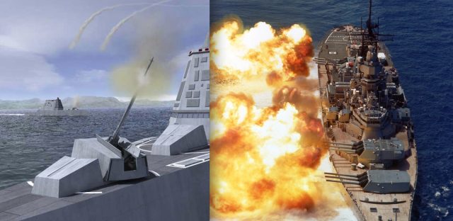
The Advanced Gun System, left, is intended
to take on the role of the battleship's 16-inch guns, right. Aside from
its GPS-guided shell, the digital technology of the AGS's fire control
system does exactly what the USS Iowa's Rangekeeper Mark 8 did—just with
fewer people and less weight.
US Navy
The USS Zumwalt, the latest destroyer now undergoing acceptance
trials, comes with a new type of naval artillery: the Advanced Gun
System (AGS). The automated AGS can fire 10 rocket-assisted,
precision-guided projectiles per minute at targets over 100 miles away.
Those projectiles use GPS and inertial guidance to improve the gun’s
accuracy to a 50 meter (164 feet) circle of probable error—meaning that
half of its GPS-guided shells will fall within that distance from the
target. But take away the fancy GPS shells, and the AGS and its digital
fire control system are no more accurate than mechanical analog
technology that is nearly a century old.
We're talking about electro-mechanical analog fire control computers
like the Ford Instruments Mark 1A Fire Control Computer and Mark 8
Rangekeeper. These machines solved 20-plus variable calculus problems in
real-time, constantly, long before digital computers got their sea
legs. They were still in use when I served aboard the USS Iowa in the
late 1980s.
There were a few efforts to marry these older systems to or replace
them with digital technology during my tour, one of which (called the
Advanced Gun Weapon System Technology Program) was remarkably like the
AGS’s 100-mile shell: a GPS and inertially guided 11-inch dart-shaped
shell wrapped in a 16-inch peel-away jacket, or sabot, that would have
been able to fly nearly as far without the rocket assist thanks to the
battleship’s big guns.
So why did the Navy never follow through with digitizing the battleship’s big guns? I asked retired Navy Captain David Boslaugh, former
director of the Navy Tactical Embedded Computer Program Office, that
question. And if anyone would know, it's Boslaugh. He played a role in
the development of the Navy Tactical Data System—the forerunner to
today’s Aegis systems, the mother of all digital sensor and fire control
systems.
“At one time, my office was asked to do a study regarding upgrading
the Iowa-class battleship fire control systems from analog to digital
computers,” Boslaugh replied. “We found that digitizing the computer
would improve neither the reliability nor the accuracy of the system and
recommended, ‘Don't bother.’” Even without digital computers, the
Iowa could fire 2,700-pound “dumb” shells nearly 30 miles inland with
deadly accuracy, within a circle of probable error of around 80 meters.
Some of its shells had circles of destruction larger than that.
Just how can a box of gears, cams, racks, and pins handle ballistics
calculations based on differential equations with dozens of variables in
real time? How does it manage to put a hunk of metal weighing as much
as a Volkswagen Beetle on top of a target over the horizon in the first
place? And how did this metal and grease out-calculate digital systems
for so long? Let's start with a little bit of a history on battleship
ballistics—complete with vintage Navy training films to show precisely
how mechanical analog computing works.
Going ballistic
Shooting things with a gun from a ship is not exactly easy. In
addition to the usual problems faced by ballistics—calculating how much
bang to apply, how high to aim to reach a target at a certain range, how
much to compensate for wind and the Coriolis effect—you have to take
into account the fact that you’re shooting from a platform that has
constantly changing pitch, yaw, and position. If you’re lucky enough to
have a stationary target, the variables are still comparable to trying
to hit something with a water balloon from the back of a hopping
kangaroo.
Shooting things within sight of a ship is a feedback loop. Aim at the
target, calculate its relative movement and other ballistic conditions,
shoot, watch where the shot falls, and adjust. Shooting targets over
the horizon is even trickier. It requires a forward observer who can
give a precise geographic fix and then give corrections based on where
shells land to walk them onto target.
In the days before turrets, ships fired guns in broadsides.
Adjustments were generally made by where the shells fell and by waiting
to fire until the side facing the enemy was on the upward side of a
roll. But with the arrival of dreadnoughts and battle cruisers at the
beginning of the 20th century, the range and lethality of ships’ guns
both rose dramatically. There was now a greater need for accuracy, too.
That need corresponded with the rise of analog computers. Mechanical
analog computers were used by astronomers for centuries to predict star
positions, eclipses, and the phases of the moon—the earliest known
mechanical analog computer, called the Antikythera Mechanism, dated to 100 BC. But nobody got around to using computers to try to kill people until much later.
Analog computers use a common set of mechanical devices to do their
calculations—the same sorts of devices that convert the torque created
by a car’s engine into turning wheels, lifting valves, and moving
pistons. Data is “entered” into analog computers continuously, usually
by the rotation of shaft inputs. A mathematical value is assigned to one
full 360-degree rotation of the shaft.
In the days of the ancient Greeks, data entry was performed by
turning a wheel. In more modern analog computers, variables from sensor
data such as speed, direction, wind speed, and other factors were passed
by electromechanical connections—synchro signals from gyrocompasses and
gyroscopic “stable verticals,” tracking systems, and speed sensors.
Constants, like passing time, were input by special constant-speed
electrical motors.
Connecting all the shafts together to turn them into a continuous set
of calculation outputs is a collection of gears, cams, racks, pins, and
other mechanical elements that translate motion into math through
geometric and trigonometric principles. This is also done through
“hard-coded” functions that store the results of more complex
calculations in their precisely machined shapes. Working together, these
parts instantaneously calculate a very precise answer to a very
specific set of questions: where will the target be when the giant
bullet I push out of a 68-foot long rifled barrel gets there, and where
do I need to aim to get it there?
When assembled precisely, analog computers can be much more accurate
than digital computers on these types of questions. Because they use
physical rather than digital inputs and outputs, they can represent
curves and other geometric elements of calculations with an infinite
level of resolution (though the precision of those calculations is based
on how well their parts are machined, and loss from friction and
slippage). There are no least significant digits dropped, and answers
are continuous rather than dependent on “for-next” clock-driven
computing cycles.
The most fundamental part of any mechanical analog computer is its
gears. By using combinations of gears of various types, an analog
computer can perform basic mathematical functions such as addition,
subtraction, multiplication, and division.
Gear ratios—the use of two gears with circumferences that are a fixed
multiple or fraction of each other—are the most basic way to do math
with machines. They can be used to scale input or output up or down or
to apply constant multiples of an input to another calculation. Turn a
shaft geared to another with a 2-to-1 ratio, for example, and the shaft
getting the output rotates half as many times.
Rack-and-pinion systems like those used in steering your car are also
used in analog computers to translate rotational motion to a linear
output—moving a readout or positioning components to solve other sorts
of calculations in the ballistics problem geometrically.
You can get an idea of how these sorts of gear-based systems work in
analog computers in this clip from a 1953 Navy training film on fire
control computers:
Shafts and gears in a fire control computer.
Differential gears are used in cars to make it possible for wheels to
rotate at different speeds in turns. But they perform a different
function in analog computers, providing a mechanical way to perform
addition and subtraction. A set of differential gears set between two
input shafts with matching gears will always make a set of rotations
that is the mathematical average of the rotations of the two inputs;
multiply that average by two and you have the algebraic sum of the two
inputs. For example, if one input shaft spins forward three times and
the other spins forward once, the differential gears will rotate their
attached shaft twice—which is half of four, the total.
Differential gears, as used in an analog computer.
All that is fine for basic math. But for higher level functions, such
as calculating things like ballistic trajectory curves or the Coriolis
effect’s impact on longer-flying shells, analog computers need more
complicated parts. Some of those functions can be handled by
cams—rotating surfaces that have been machined to “store” the answers
for a range of values. Simple cams can store a range of answers based on
a single variable, such as turning an input rotation into a
trigonometric or logarithmic output through the movement of a pin
connected to a rack. More complex, three-dimensional “barrel” cams can
store answers to complex two-variable functions as a rotational volume,
as demonstrated in the film clip below.
Cams, the stored functions of analog computing.
All of these components were well-known to the makers of early
celestial calculators, though their machining may not have been nearly
as precise as could be achieved with the tools of the Industrial Age.
But there’s one last mechanical component that brought everything
together for the advanced calculations required in predicting a target’s
location in ballistic calculations: the integrator. It's a device that
uses the differing rates of rotation on a spinning disc to act as an
infinitely variable differential gear.
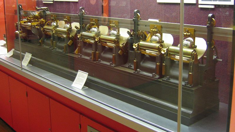
First fully developed by Prof. James Thompson of Belfast in 1876, the integrator was further refined by his brother Lord Kelvin as the element of a “harmonic analyzer.”
Enlarge/ Lord Kelvin's "harmonic analyzer," with disk integrators.
Lord Kelvin used the harmonic analyzer to isolate the multiple
factors affecting tidal patterns so they could be predicted in the
future. The computer took in two inputs: time was input as a steady
rotation, while the tide height was traced from a recording with a
mechanical needle. Wires and pulleys generated the output, drawing a
curve on a roll of paper. The Royal Navy loved Kelvin’s tide computer
because it allowed them to take historic tide data recorded anywhere in
the world and generate tide tables with a fraction of the work. More
than a half-century later, Lord Kelvin’s tide computers helped in planning the D-Day landings at Normandy, thus contributing directly to the outcome of World War II.
Aside from refinements to make it more reliable under the demanding
conditions of shipboard operation, the integrators in fire control
computers in operation through the 1990s were essentially the same as
those used by Lord Kelvin in function, as shown in the video below.
Hannibal Ford, the man who designed the Rangekeeper and Mark 1 fire
control computers, invented this improved integrator, which uses a pair
of balls in a carriage to transmit rotation information from the turning
disc.
A
disc-type integrator, as used in the Mark 1 Fire Control Computer, is
similar in design and function to Lord Kelvin's integrator.
The network is the (fire control) computer
The fire control “systems” of the First World War were largely
standalone pieces connected by people shouting over phones and voice
tubes. The only data that came into the Rangekeeper Mark I automatically
was the ship’s course, thanks to a gyrocompass repeater. That would
change over the next decade as the navies of the world got more
comfortable with this newfangled thing called electricity.
The Washington Naval Treaty of 1922 ratcheted back naval development
for nearly a decade, but Ford continued the development of the
Rangekeeper through the '20s, culminating in 1930 with the Rangekeeper
Mark 8. The Mark 8 would be the zenith of big naval gun fire control. It
was the system used aboard Iowa-class battleships to direct the ships’
16-inch guns, and it calculated every broadside from the four ships
since their commissioning in World War II until their bombardment of
Iraqi troops in the Gulf War in February of 1991.
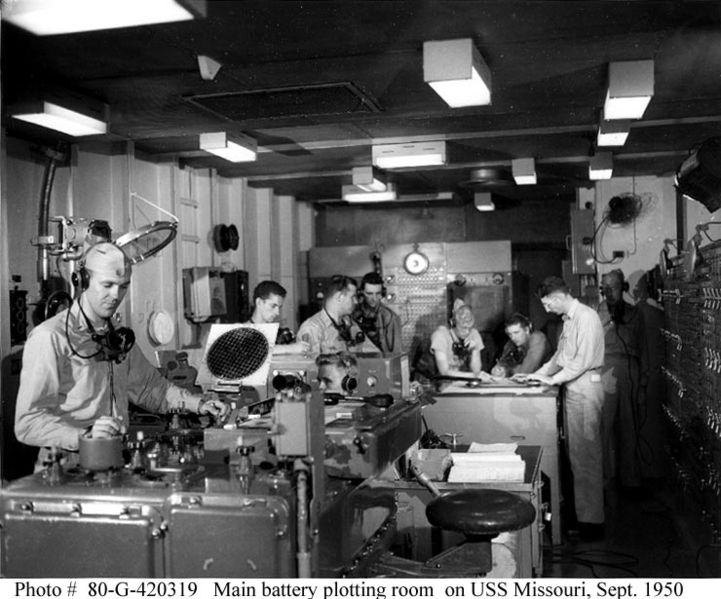
Enlarge/
The Main Battery Plot room aboard the USS Missouri, where the
Rangekeeper Mark 8 and its associated analog computing hardware was
tended to. The switchboards on the wall controlled which turrets and
guns were under the system's control.
The Rangekeeper Mark 8 still gave operators the option of manually
entering data just in case a connection to a sensor failed, and they
could also override or adjust data based on observation of shot and
other corrections. The machine could even be operated without
electricity by turning a hand crank. Target bearing and range now came
in as electrical inputs from a gun director. A ship’s speed was fed in
using data from the ship’s pitot tube automatically, and wind speed was
inputted directly from an anemometer.
Once the system was “locked” on a target, the Mark 8 would send
signals through a switchboard to the gun turrets and mounts to keep them
aimed properly, next sending stabilizing data to adjust the elevation
of the guns for the ship’s yaw and pitch. The Mark 8 was itself
electromechanically networked. It consisted of five boxes of analog
computing hardware bolted together into a single unit.
The Mark 8 was for the big guns, which were strictly for surface
targets because of their size and rate of fire. Smaller guns, like the
5-inch 38 caliber dual-gun mounts on the Iowa and many of the other
smaller warships of the World War II era, needed to be able to target
faster, smaller targets in three dimensions—plainly speaking, airplanes.
This required much more complex calculations, leading to the pinnacle
of electromechanical analog computing: the Ford Instruments Mark 1 Fire
Control computer.
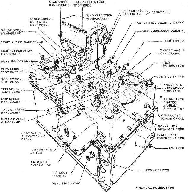
The Mark 1A Fire Control Computer—3,000 pounds of aluminum alloy computing power.
The Mark 1 weighed over 3,000 pounds. Like the Rangekeeper, it took
inputs from gun directors—electromechanically driven turret-like
“barbettes” with optical (and eventually radar) sensors that
continuously sent bearing and range information via electrical synchro
signals.
The computer took into account parallax between the director and the
guns it was controlling. It also had to calculate fuse times for
mechanical fuses to ensure that the shell would explode near the target.
(That said, there were a few times in gunnery practice in the 1980s
when the Iowa directly hit a towed aerial target, albeit not on
purpose.)
Considered to be the most accurate anti-aircraft computer in service
during the war, the Mark 1 still had some serious limitations. It
depended on mechanical fuses to explode shells near airborne targets,
and it could only handle calculations on aerial targets moving at less
than 400 knots relative horizontal and 250 knots relative vertical
speed. That made it ineffective against jets and kamikaze attacks.
Enlarge/
The Mark 48 "shore attack" computer, an electrical analog system with
electromechanical inputs. It had a light table for charts that projected
position and target data from below.
So why did we ever move away from using these mechanical marvels to
lock onto things and blow them up? While highly accurate, mechanical
analog computers have a few limiting factors. They’re heavy. They take
up a lot of space. Even as they became more automated, they still
required many minders. The torque required to make them work, including
all the servos that converted electrical signals to rotation, required a
lot of electricity—16 kilowatts at peak consumption.
And while they’re generally reliable, their greatest enemies are
friction and mechanical fatigue. Keeping a fire control computer
properly lubricated and watching for gear wear is a bit more of a chore
than dropping by the local garage for an oil change. Then there’s the
issue of “reprogramming” an analog computer. If you want to change the
range of inputs they handle or modify the output to account for new
variables, that requires the equivalent of a transmission rebuild.
For most applications that analog computers were built for, that
wasn’t a problem. The variables of fire control were pretty well set for
most of the last century. The arrival of jet aircraft and the need to
handle more long-range bombardment of land targets led to a new round of
innovations in analog systems that lasted through the mid-1970s:
electrical analog systems.
These electronic computing systems weren’t digital, and they
performed the same sorts of functions as gears and cams with analog
electronic components. But the electronic parts were lighter and easier
to maintain than full-on mechanical systems, and they could integrate
with mechanical systems through signal outputs similar to the synchros
used to integrate other sensors.
During World War II, Bell Labs developed the first all-electronic
fire control computer, the Bell Mark 8. While it never saw service,
parts of the technology were married with an upgrade for the Ford Mark
1, designated the Mark 1A. The improved system helped track and target
faster aircraft.
The Mark 1A and the Rangekeeper Mark 8 also got some extra electrical help for land targets during the Korean War. The Mark 48 “shore attack” computer was
designed specifically to handle “indirect fire”—shooting at things that
the ship couldn’t see based on information from a spotter plane, a
forward observer, or (starting in the late 1980s) a Pioneer drone. It
used the existing director system to point at a known reference point,
typically a geographic feature identified on a chart. It could also use
radio or satellite navigation signals to fix the ship’s position. The
Mark 48 then calculated the fire control solution based on the fix and
the location provided for the target, pushing the data over to the
Rangekeeper or Mark 1A, depending on which guns were being used to
bombard the unfortunate target at the other end.
Legacy systems
The four Iowa-class battleships were the only ships ever to get the
Mark 48. For the rest of the fleet, the switch to digital fire control
systems started in the mid-1970s, as ship designs moved toward being
lighter and more focused on hunting submarines and aircraft than on
shooting other ships.
.
The
author as a young Navy officer aboard the USS Iowa in 1988, just
outside the armored citadel on the bridge that sat below the director
for the fire control system the Rangekeeper Mark 8 was part of.
I served aboard the Iowa in the Deck Department in 1987 and 1988,
nominally in charge of 125 boatswain’s mates and unrated seamen. Many of
the men who were in my division manned Turret Two or one of the ship’s
5-inch gun batteries, so I had more than a passing interest in how
things worked. I spent a good deal of time crawling through the shell
decks of the turret making sure everyone was where they were supposed to
be.
During my time aboard, we fired more shells from the ship’s 16-inch
guns than Iowa fired in the entire Korean War. And despite all the
experiments in adding digital technology to the gun system, one simple
sensor installed just before my arrival made the guns more accurate than
they ever had been before——a Doppler radar sensor that could detect
shell velocity as it left the barrel.
The radar was installed after the USS New Jersey had been rushed back
into service in the early 1980s, and it experienced major problems with
the accuracy of its guns during the Beirut crisis.
The problems were largely due to the fact that the bags of gunpowder
used aboard the ship had been re-mixed and its explosive profile had
changed.
By accurately measuring the gun’s muzzle velocity on the first shot
with a particular lot of gunpowder bags, the fire control crew could get
an idea of what it would be for other shots and change the velocity
input for the computer accordingly. I saw that accuracy firsthand aboard
Iowa on a couple of occasions, including a one-night gunfire exercise
off the coast of Vieques, Puerto Rico. Using inert training rounds, the
gunners hit a metal target dead-on, and I could see the sparks fly from
the collision from several miles away.
The final testament of the battleships’ accuracy came during the Gulf
War, when the USS Missouri and USS Wisconsin used Pioneer drones as
spotters to attack Iraqi artillery batteries and bunkers. It was after a
bombardment by the Missouri that Iraqi troops on Faylaka Island
surrendered to a drone off the Wisconsin, associating the drone’s low
pass with another imminent bombardment.
The real end of analog fire control came not because of accuracy, but
simply because of dollars and cents. The Navy could crew 10 USS
Zumwalts with what it took to put the Iowa to sea, and it could fuel
twice as many with what it took to top off the battleship’s tanks. The
Navy spent much of the 1980s and 1990s trying to justify keeping the
battleships in service despite their cost, attempting to use things like
the Advanced Gun Weapon System Technology Program or using the spaces
for testing higher-powered gunpowder loads. The 1989 explosion aboard
the Iowa—possibly caused by spontaneous combustion of the gunpowder
milled in the 1930s—put an end to that experimentation.
Ironically, analog computing technology lives on aboard the Zumwalt
as part of its fire control system. Electronic analog computers are part
of the phased-array radar system that aims Zumwalt’s missiles. Still,
in the eyes of older Navy vets, it’s not really a fire control computer unless it has servos.


