


The popular image of modern warfare is the digital battlefield where cyber soldiers have Terminator-like video displays and can call in an airstrike with the shine of a laser beam. While information technologies are revolutionizing the military, when it comes to calling in Close Air Support (CAS), it’s still World War One – where a misread or misheard grid reference can end up with soldiers being hit by their own artillery. DARPA’s Persistent Close Air Support (PCAS) program hopes to improve this.
Smart bombs, laser targeting and intelligent missiles have made laying a munition on exactly the desired spot so common that it’s hardly newsworthy. For most ground commanders, however, calling in CAS still involves pilots and ground observers relying on voice directions and a common paper map, which isn’t always available. It can take up to an hour for a strike to be arranged, during which time an enemy can escape or get in the first punch, and even then there’s an ample chance of a fatal error.
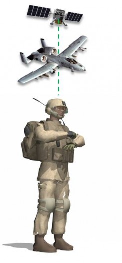
The PCAS program is an all-digital system that lets a joint tactical air controller call up CAS from a variety of sources, such as aircraft or missile platforms, to engage multiple, moving and simultaneous targets. By eliminating all the radio chatter and map fumbling, the exercise is much faster and more accurate with reduced risk of friendly fire incidents.
DARPA describes PCAS as a “system of systems” that uses commercial IT products and models such as open interfaces, element modularity and mobile software applications. Generally, it consists of manned and unmanned aircraft, next generation graphical user interfaces, data links, digital guidance and control, and advanced targeting and visualization tools. In practice, it breaks down into two major component systems.
The first is PCAS-Air, which as the name suggests, deals with airborne assets. It involves the use of internal guidance systems, weapons and engagement management systems, and communications using either the Ethernet or aircraft networks for high-speed data transmission and reception. PCAS-Air processes the data received, and provides aircrews via aircraft displays or tablets with the best travel routes to the target, which weapons to use, and how best to use them.
The other half is PCAS-Ground, intended for improved mobility, situational awareness and communications for fire coordination. Soldiers on the ground can use an HUD eyepiece wired to a tablet that displays tactical imagery, maps, digital terrain elevation data, and other information. This means they can receive tactical data from PCAS without having to keep looking at a computer screen. Coordination with airborne pilots is achieved through in-flight GPS tracking.

“The Smart Rail is an easy way to get digital air-ground coordination onto current and future aircraft,” Patt says. “Just as the USB revolutionized how we use IT-enabled devices, modular technologies like the Smart Rail could greatly reduce development time and costs for military technology and speed deployment of PCAS and other capabilities across the Services.”
From December 2012 through March 2013, PCAS deployed PCS-Ground to Afghanistan using 500 Android tablets equipped with PCAS-Ground situational awareness software. According to DARPA, field reports indicated a drastic improvement over the use of paper maps.
Source: DARPA
No comments:
Post a Comment